20th Century |
| Pre-History | 16th-18th Centuries | 19th Century | 20th Century | 21th Century |
| Visit the main River Returns web site >> |
| |
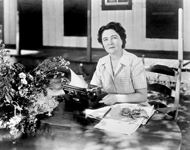
© Florida Memory Project
|
Early 1900s
Draining of The Headwaters Begins
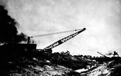
Throughout the early 1900s, a network of private canals, ditches and levees were carved through the marshes of the Upper St. Johns River Basin, draining the wetlands and converting more than 70 percent of its headwaters into agricultural and urban lands.
|
|
© Ditches and Dreams: Nelson Fell and the Rise of Fellsmere / Florida Heritage Collection
|
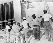
1915
Fellsmere Farms Fails
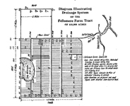
Nelson Fell, a hydraulic engineer from England, created the Fellsmere Farms Company and attempted to drain a 450-square-mile parcel of the river's headwaters for farming. In 1915 - after digging 67 miles of canals and 215 miles of ditches - two days of rain flooded the town of Fellsmere and destroyed much of the drainage system that kept the wetlands arable. Fellsmere never recovered.
|
|
|
1921
The First Car Bridge in Jacksonville
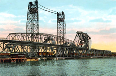
In 1921, the first vehicle and pedestrian bridge was built across the river in Jacksonville. For centuries, people had experienced the St. Johns River by traveling its surface in boats for sustenance, trade and tourism. From this point onward, the most common human experience with the river would be one of crossing over it.
|
|
© Florida Memory Project
|
1925
A Tourism and Real Estate Boom
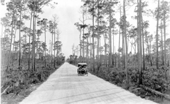
A Suniland magazine article touted Florida's comfortable hotels and the tropical sunshine at the "utopian Land's End of the U.S." Prose such as this, aided by 11,000 miles of improved roads, created a tourism and real estate boom in Florida, including the St. Johns River region, which reached its peak just before the Great Depression.
|
|
© Florida Memory Project
|
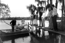
1942
Marjorie Kinnan Rawlings
In the 1930s, Pulitzer Prize winning author Marjorie Kinnan Rawlings explored the St. Johns River in a small boat. In her book Cross Creek, published in 1942, Rawlings wrote of her beloved river: "If I could have, to hold forever, one brief place of time and beauty, I think I might choose the night on the high lonely bank above the St. Johns River."
|
|
© Florida Memory Project
|
1954
Congress Authorizes Flood Control Project
The loss of floodplain marshes in the Upper St. Johns due to drainage canals resulted in devastating floods from hurricanes in the 1920s and 1940s. In 1954, Congress authorized flood-control projects in the Upper St. Johns Basin. During the next two decades the Army Corps of Engineers would build a canal system delivering huge volumes of freshwater into the Indian River, a saltwater lagoon.
|
|
© Florida Memory Project
|
1964
Disney World Comes to Florida
Walt Disney set his sites on Florida, a place where land was cheap, the weather was warm and people were eagerly going to live or to vacation. Quietly, under dummy corporations, Disney bought 27,000 acres - about twice the size of Manhattan. Disney World was born and when word got out area land prices jumped from $183 per acre to over $1,000 per acre. Orlando, then a quiet town of 20,000 people surrounded by orange groves and wetlands, would never be the same again.
|
|
© Florida Memory Project
|
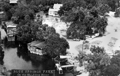
1971
Jacques Cousteau Films Manatees
Jacques Cousteau filmed manatees at Blue Springs on the St. Johns River, a major winter habitat for the marine mammals. The documentary, "The Forgotten Mermaids," helped focus international attention on the plight of manatees and was a catalyst for the State's purchase of Blue Springs and several hundred acres of land along the river.
|
|
© St. Johns River Water Management District
|
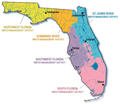
1972
The Water Resources Act
To manage all freshwater resources in Florida, the Water Resources Act was passed, establishing five water management districts in Florida, among them the St. Johns River Water Management District, covering about 23 percent of Florida's area.
|
|
© Jill Heinerth / Karst Productions
|
1974
Flood Control Project Is Halted
The Army Corps of Engineers flood control project authorized in the '50s for the Upper St. Johns River Basin was halted when it was determined to be harmful to the environment of the Indian River Lagoon.
|
|
© Russell Sparkman / Fusionspark Media
|
1975
The Aquatic Preserve Act
Florida established the Aquatic Preserve Act, protecting the aesthetic, biological and scientific values of its waterways for the enjoyment of future generations. Two of the St. Johns River's major tributaries - the Wekiva and the Oklawaha Rivers, including a 20 mile stretch of the St. Johns - received protection.
|
|
© Russell Sparkman / Fusionspark Media
|
1978
The Manatee Sanctuary Act
The Manatee Sanctuary Act declared the entire state of Florida as a refuge and sanctuary for the East Indian Manatee, or sea cow. The act regulated boat speeds on the St. Johns and established Blue Springs State Park as a designated protection zone.
|
|
© Russell Sparkman / Fusionspark Media
|
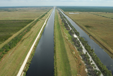
1988
Restoration of the Upper St. Johns Begins
A decade after planning started, two agencies - the St. Johns River Water Management District and the Army Corps of Engineers - began restoration of 150,000 acres of the Upper St. Johns River through land acquisition and by plugging drainage canals and building reservoirs. These actions provided flood control while also restoring the sheet flow of water through the river's headwaters. This restoration project became a model for Everglades restoration.
|
|
© Russell Sparkman / Fusionspark Media
|
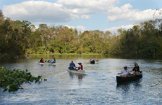
1990
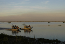
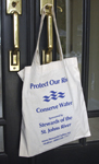
Citizen Groups Protect the River
The Stewards of the St. Johns River, a coalition of citizens, was organized to increase the public's awareness of health and quality issues related to the St. Johns River. The Stewards are one of several private or non-profit groups, including the St. Johns Riverkeeper and the Florida Defenders of the Environment, working to preserve and protect the St. Johns River.
|
|

© Russell Sparkman / Fusionspark Media
|
1991
Stick Marsh and Farm 13
As a component of the Upper St. Johns River restoration project, the St. Johns River Water Management District created a 6,500-acre reservoir to help filter runoff from, and provide irrigation water to, agricultural areas. The area, known as Stick Marsh and Farm 13, opened to fishing in 1991 and has become one of Florida's premier bass fishing spots.
|
|

|
1997
The First River Summit
The first River Summit drew hundreds of citizens, business leaders and government officials to discuss issues related to water quality in the Lower St. Johns River Basin. As a result, projects were developed to reduce point and non-point pollution, restore degraded habitat, reduce bacteria in tributaries and improve water quality compliance and enforcement.
|
|
© Clinton White House Web Site
|
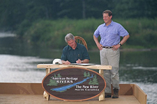
1998
American Heritage River Designation
President Clinton designated the St. Johns River an American Heritage River, one of only 14 rivers so recognized in the country and the only one in Florida. The designation inspired the forming of the St. Johns River Alliance in 2003, a non-profit public-private partnership organized to protect the river.
|
|
|
1999
The Florida Forever Act
Nine years after former Governor Bob Martinez's government determined that the state would lose three million acres of wetlands and forests to "other uses" by the year 2020, Governor Jeb Bush signed the Florida Forever Act. The 10-year, $3 billion program allows the state to acquire and improve lands and water areas, and opened the way for the state to purchase and protect land along the St. Johns River.
|
|
© Russell Sparkman / Fusionspark Media
|
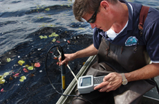
1999
The Watershed Restoration Act
The Watershed Restoration Act of 1999 authorized the Department of Environmental Protection to administer and coordinate the state's Total Maximum Daily Load (TMDL) program. Setting TMDLs, a requirement of the federal Clean Water Act of 1972, establishes maximum amounts of pollutants a watershed like the St. Johns River can assimilate and provides agencies with standards of measurement for watershed management.
|
|
